Mount Rainier Volcano: Height, Last Eruption, Lahar Risk
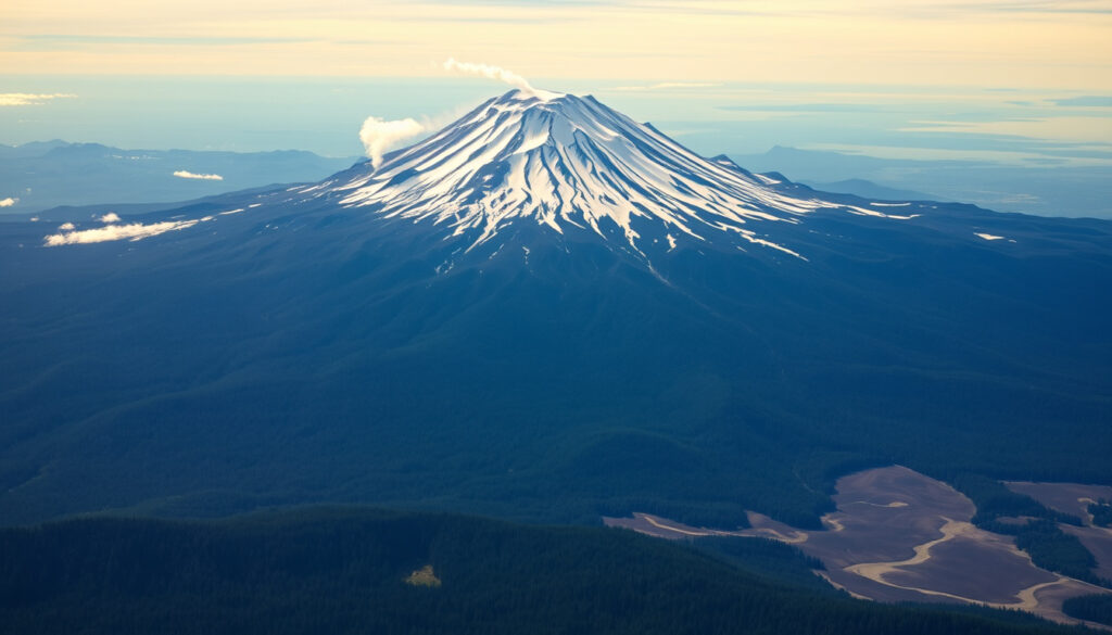
There’s a reason Mount Rainier dominates the Seattle skyline—and it’s not just its size. Beneath its icy summit lies a dangerous secret: this glacier-capped stratovolcano is considered one of the most threatening volcanoes in the United States, not because it erupts often, but because when it does, mudflows called lahars could race toward hundreds of thousands of people in minutes.
Elevation: 14,411 ft (4,392 m) ·
Last eruption: ~1894 ·
Glaciers: 25 major glaciers ·
National park established: 1899 ·
Distance from Seattle: 59 miles (95 km) ·
Volcano type: Active stratovolcano
Quick snapshot
- Mount Rainier is an active volcano (Pierce County, Washington (local government))
- It last erupted around 1894 (KATV local news affiliate)
- Lahars are the greatest hazard (Seattle Office of Emergency Management (city agency))
- Exact date of next eruption unknown (The New York Times (major newspaper))
- Predicted eruption in 2026 is speculative for Rainier (The New York Times (major newspaper))
- Last eruption: ~1894 (small steam explosions)
- Major lahar ~5,600 years ago (Osceola Mudflow)
- National park established 1899
- USGS continuous monitoring (Pierce County)
- Lahar detection system in Puyallup valley (City of Puyallup (municipal government))
These five figures capture Mount Rainier’s scale and risk profile.
| Attribute | Value |
|---|---|
| Elevation | 14,411 ft (4,392 m) |
| Last eruption | ~1894 |
| Primary hazard | Lahars (volcanic mudflows) |
| National park size | 236,381 acres |
| Closest major city | Seattle, WA (59 miles) |
The pattern: Height and ice volume make Rainier beautiful, but those same features amplify its destructive potential.
What is so special about Mt. Rainier?
Mount Rainier isn’t just the tallest peak in the Cascade Range — it’s the most heavily glaciated mountain in the contiguous United States. Pierce County’s hazard guide (local government) notes that its 25 major glaciers and vast ice caves make it a unique outdoor destination — and also a ticking clock.
Why is Mount Rainier the most glaciated peak in the contiguous US?
- 25 named glaciers cover roughly 35 square miles of the mountain.
- Rainier’s glaciers are the largest ice cave system in the lower 48 states (USGS (federal science agency)).
Is Mount Rainier an active volcano?
Yes, and that status is the key to understanding its danger. Pierce County states plainly: “Mount Rainier is an active volcano.” The U.S. Geological Survey classifies it as a stratovolcano capable of producing explosive eruptions and massive lahars.
An active volcano under a thick ice cap means an eruption could rapidly melt ice and send mudflows racing into populated valleys. That combination makes Rainier uniquely dangerous among U.S. volcanoes.
The catch: Rainier’s beauty and activity are inseparable — the same ice that draws climbers could fuel its deadliest event.
When was the last time Mount Rainier erupted?
Mount Rainier’s most recent eruptive activity consisted of small steam explosions around 1894, according to records compiled by KATV (local news affiliate). However, some sources, including the Arizona Geological Survey (state agency via social media), reference a longer gap — roughly 1,100 years since a significant eruption.
What is the eruption history of Mount Rainier?
- The volcano began forming approximately 500,000 years ago.
- Major lava flows and lahars have occurred over millennia, with the Osceola Mudflow (~5,600 years ago) reaching Puget Sound.
- Since the last eruption in the late 1800s, only fumaroles and steam vents have been observed.
How do scientists monitor volcanic activity at Rainier?
The USGS Cascades Volcano Observatory (federal agency) uses seismometers, GPS stations, gas sensors, and satellite imagery to detect any changes. The monitoring network is part of a nationwide warning system, but predicting the exact date of an eruption remains impossible.
The trade-off: While the long quiet period suggests a low probability of eruption this year, it also means pressure can build silently over decades.
Which areas are at risk if Mount Rainier erupts?
The primary threat from Mount Rainier is not lava but lahars — fast-moving slurries of mud, rock, and water. Pierce County’s emergency guide warns that lahars can travel 45–50 miles per hour and reach heights of 100 feet in the Puyallup River valley.
What is a lahar and how dangerous is it?
A lahar is a volcanic mudflow triggered by rapid melting of snow and ice or by a landslide. A USGS educational video (federal agency) explains that lahars can occur with or without an eruption, making them especially unpredictable. The New York Times (major newspaper) reported that a lahar could reach populated areas in about 45 minutes.
How many people live in lahar hazard zones?
According to the Seattle Office of Emergency Management (city agency), over 80,000 residents live in mapped lahar hazard zones along the Puyallup, Carbon, and Nisqually river valleys. The City of Puyallup (municipal government) has its own lahar evacuation plan, underscoring the seriousness of the risk.
For communities from Enumclaw to Tacoma, a lahar event isn’t a matter of if but when — and the window for escape is measured in minutes, not hours.
Why this matters: Population density in the lahar paths makes Rainier the most dangerous volcano in the Cascade Range for human life, even though it hasn’t had a major eruption in centuries.
Which is bigger, Mount Rainier or Mount St. Helens?
In height, Mount Rainier wins by a wide margin: 14,411 feet compared to Mount St. Helens’ 8,366 feet (post-1980). But “bigger” means different things when you consider eruptive history and hazard type.
Height comparison: Mount Rainier vs Mount St. Helens
| Feature | Mount Rainier | Mount St. Helens |
|---|---|---|
| Elevation | 14,411 ft (4,392 m) | 8,366 ft (2,550 m) |
| Last major eruption | ~1894 (small steam) | May 18, 1980 (catastrophic) |
| Primary hazard | Lahars from glacial melt | Explosive eruptions + lahars |
| Glacier cover | 25 major glaciers | Crater Glacier (since 1980) |
| Proximity to metro area | 59 miles from Seattle | 96 miles from Portland |
Volcanic threat comparison
The Seattle Office of Emergency Management (city agency) ranks Rainier as the bigger risk to the Puget Sound region precisely because its massive ice cap can generate much larger lahars, and because it sits closer to dense population centers. Mount St. Helens, however, remains the more explosively active volcano in historical times — its 1980 eruption column rose about 80,000 feet (Wikipedia) and deposited ash across 11 states.
The pattern: If the contest were about height alone, Rainier wins. But for explosive power and recent history, St. Helens takes the lead. The real danger lies in what each volcano’s specific features threaten.
What will happen if Mount Rainier erupts?
An eruption would trigger several cascading hazards, with lahar the most immediate and deadly. The City of Puyallup describes a lahar that could be 100 feet high and travel at highway speeds. Ashfall would disrupt air travel and water supplies over a broad region.
What is a lahar and how would it affect Seattle?
Seattle itself sits at a higher elevation and would not be directly hit by the largest lahars, which are channeled into river valleys. However, the Seattle Office of Emergency Management (city agency) notes that ashfall could collapse roofs, disable vehicles, and contaminate water supplies. The Port of Seattle and Sea-Tac Airport could face prolonged closures.
Even a small eruption under the summit glaciers can melt enough ice to produce a lahar that reaches populated areas — that’s why USGS and local agencies maintain round-the-clock monitoring.
The implication: The eruption itself may be small, but the secondary effects — lahars, ash, infrastructure paralysis — could ripple across the entire region.
How far is Mount Rainier from Seattle?
Mount Rainier sits about 59 miles (95 km) southeast of Seattle as the crow flies. Driving to the park’s Nisqually entrance takes roughly 2 hours without traffic. On clear days, the mountain is an iconic part of the Seattle skyline, visible from downtown’s Kerry Park or the Space Needle.
Can you see Mount Rainier from Seattle?
Yes — on clear days, the mountain is a dominant presence on the southern horizon. The National Park Service (federal agency) notes that visibility is best in winter and early spring when the air is dry and the mountain is snow-covered.
The trade-off: That stunning view is a constant reminder that a sleeping giant lies just an hour’s drive from Washington’s largest city.
Timeline: Key events in Mount Rainier’s volcanic history
- ~500,000 years ago: Mount Rainier began forming as a stratovolcano.
- ~5,600 years ago: Osceola Mudflow — large lahar that reached Puget Sound.
- ~2,600 years ago: Electron Mudflow — another significant lahar event.
- 1894: Last recorded eruption (small steam explosions).
- 1899: Mount Rainier National Park established.
The pattern: Major lahars occur roughly every 3,000 years — and the last one was over 5,000 years ago, meaning the region is statistically overdue for a large mudflow event.
Confirmed facts vs. what’s unclear
Confirmed facts
What’s unclear
- Exact date of next eruption unknown (NYT).
- Whether a “2026 eruption” prediction for Rainier has any scientific basis — most forecasts focus on other Cascades volcanoes.
The catch: While scientists can confirm many facts about Rainier’s past and present, predicting the timing of the next eruption remains impossible — and that uncertainty is itself a reason to take the hazard seriously.
What experts say about Mount Rainier’s risk
“The greatest hazard posed by Mount Rainier is from lahars — volcanic mudflows that can occur with or without an eruption and can travel at speeds of 45–50 miles per hour.”
— USGS Cascades Volcano Observatory (federal agency), in their monitoring overview
“Mount Rainier is an active volcano that is the most glaciated peak in the contiguous United States. The combination of volcanic activity and heavy ice cover makes it especially hazardous.”
— National Park Service (federal agency), on the park’s natural features
Why this matters: Both federal agencies agree: the lahar risk is real and demands constant vigilance.
Preparing for Rainier’s next move
For residents of the Puyallup valley, the question is not if a lahar will come, but when. Having a family evacuation plan, knowing the lahar routes, and staying aware of USGS alerts could make the difference between safety and catastrophe. For visitors, understanding the risks doesn’t mean avoiding the mountain—it means respecting what lies beneath the ice.
For Washington state emergency managers and the 80,000+ people in hazard zones, the choice is clear: invest in early warning systems and community preparedness, or face the aftermath of a fast-moving mudflow with no plan.
Related reading: **Bodies on Everest: Who, Where, and Why They Remain** · **Blood Pressure: Normal Ranges, Symptoms, and Lowering Tips**
For a more in-depth look at the volcano’s hazard profile, consult the detailed eruption risk guide from Canada Current.
Frequently asked questions
Can you drive to the top of Mount Rainier?
No — no road reaches the summit. The highest drivable point is Sunrise (6,400 ft) or Paradise (5,400 ft), both inside Mount Rainier National Park.
Is Mount Rainier erupting now?
No. The volcano is active but quiet, with only steam vents and minor seismic activity.
How many people climb Mount Rainier each year?
About 10,000–13,000 people attempt the summit annually, with roughly half succeeding, according to the National Park Service.
What animals live in Mount Rainier National Park?
The park is home to black bears, mountain goats, elk, deer, marmots, and over 130 species of birds.
How old is Mount Rainier?
Mount Rainier began forming around 500,000 years ago through successive lava flows and volcanic deposits.
What does the name Rainier mean?
The mountain is named after British Admiral Peter Rainier by Captain George Vancouver in 1792.
Is Mount Rainier a supervolcano?
No — it is a stratovolcano, not a supervolcano. Its eruptions, while dangerous, are not on the scale of Yellowstone or other supervolcanic systems.
More related posts
 Gaten Matarazzo Movies and TV Shows: Complete Filmography
 When Is Easter 2026 – April 5 Date, Good Friday and Facts
 Peter Dinklage: Biography, Health, Family, Net Worth
 Mario Lemieux: Biography, Net Worth, Penguins Owner
 Allison Williams: Career, Personal Life, and Nepo Baby Debate
 Indiana Fever vs Atlanta Dream Match Player Stats 2025
 Alex Cooper Net Worth: From $70K to a $125M Deal
 But I’m a Cheerleader – Plot, Cast and Legacy Guide